Starting mileage: 4757 Starting time: 8:30 am
Ending mileage: 5176 Ending time: 7:15 pm
Travel mileage: 419 Travel time: 10:45 hours
We passed over the mouth of the Columbia River which is where Lewis and Clark finished their expedition. There is a port at the mouth of the river and we watched a huge freighter being loaded with tree-length logs which must have been 30' high. They were probably destined to China or Japan.
Following south the terrain becomes more mountainous along the cost and the view of coast and ocean is much prettier, like the California coast along Big Sur.
There was much more obvious logging in Oregon being done through sectional clear cutting. You can see patches that are probably a few thousand feet across that have been logged at different times and have trees regrown to different heights. The logging reduces the old monoculture stands of trees that are more susceptible to fire - a major concern here. It would be interesting to see how the logging is done on some of the hills that are exceptionally steep, too steep for usual logging equipment. Much of the forest appears to be Douglas Fir, the Oregon state tree.
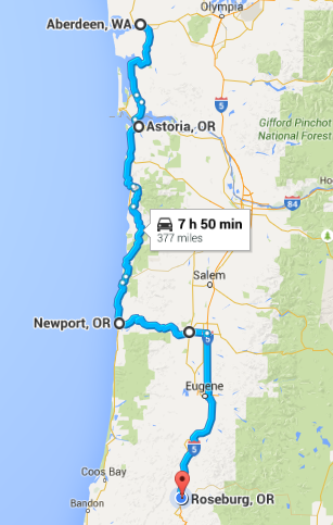
The drive down route 101 (Pacific Coast Trail) is scenic but slow-going due to the hills, winding roads, many RVs and logging trucks. In order to reach our hotel at a reasonable time, we decided to head east at Newport to reach I-5 down to our hotel in Roseburg.
Before turning east we saw a sign for a historic lighthouse at Yaquina Point and decided to check it out. This is managed by the BLM (Bureau of Land Management) and we were able to get in without charge using our national senior pass. There is a very nice visitor center with interpretive displays and a video on the history of the lighthouse which had someone living there until the 1960s. When we went out to the lighthouse, we could see whales off the point spouting and diving, showing their tail flukes as they went down.
After we crossed over the mountains to the Interstate, we were in a wide, very flat valley. It is hard to tell what is grown here as everything appears to have been harvested. Some of the fields had hundreds of sheep grazing. It is much drier here and the hills look like California, golden brown where they aren't covered with trees.
We were ready to call it a day when we got to our hotel, a Comfort Inn, around 7:30. Dinner at Elmer's, a family restaurant across the street.
The temperature was comfortable and in the mid-60s all day although it was cool standing out in the wind.
Day 17 route
Yaquin Lighthouse

Carmen at Lighthouse

Sunset from our hotel in Roseburg

No comments:
Post a Comment